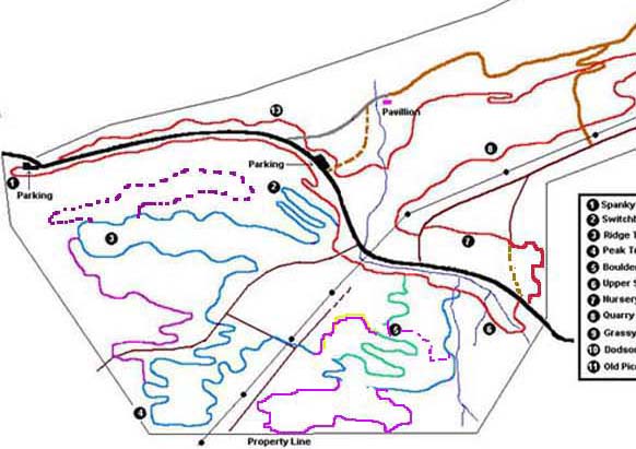
Here's a little part of the Luby's map that shows another trailwork idea I have for sals. since I have the lymo I've haven't been doing much so I've taken a bunch of little hikes over there. This area is the woods near the boulder trail.
There are about 3 parts to this , and some are fairly clever! It all starts with what I was talking about a month or so ago-hooking into the boulder trail from a different spot. This new lead in to the cool part of the boulder trail would be downhill and have lots and lots of rocks to warm you up for the main part of the boulder trail(new part is dashed purple line on map).
The next idea is that once you crossed the powerline from the peak trail you would immediately head downhill back towards Constitution(purple on this map). This area is cool and it would be great to have a trail along the powerline. Then you would hook into what is now the approach to the boulder trail-the dirt singletrack part with a small amount of rocky stuff. You would climb this back up to the bypass(reverse direction to what you normally do now).
From there we would add more trail that would go all the way up to the property line near the cable tv company, by the 3rd tower(this trail is represented by a solid purple line). Then of course you head downhill back to what is now the bypass and head down to the red trail. This added singletrack would be important in the future if we ever can get through over to the Western side. It would be through this area.
A few +'s for this idea-its pretty close to the road, it doesn't have a lot of spice bush, its one of the last places to add new trail except for the lower spanky, it adds to the main loop as its not a side option.
As far as our upcoming trailwork later this year we need to do something like this or start on the Western side or both. If anyone wants to hike this out just let me know.